We spent several more days with family in Helena and then headed south for Pueblo, CO. Here are some photos we took along the way.
 |
| Canyon Ferry Lake, MT |
 |
| Southeastern Montana early morning. |
 |
| Leaving Montana |
 |
| Our hosts at our first night stop, the 7th Ranch RV Park in Gerryowen, Montana. They were' neigh'borly! |
 |
| Entering Wyoming. The roads are pink because they use local slate for the highways. |
 |
| The Bighorn Mountain Range in Wyoming. |
 |
| Low lying clouds over the range. |
 |
| Pronghorn antelope feasting in a farmer's field. |
 |
| Coming into Casper, Wyoming. |
 |
| After Casper mostly desolation. |
 |
| Driving into Denver, Colorado. |
 |
| Mile High Stadium. |
 |
| All the sound barriers along the interstate had different patterns sketched into the stone. |
 |
| Castle Rock, Colorado. |
 |
| The clouds and the mountains merge. |
 |
| Pike's Peak from Colorado Springs. It already has snow. |
 |
| One of my favorite pictures. Awesome! |
 |
| Storms rolling in along the way. |
 |
| Lake Pueblo State Park. Totally different terrain. |
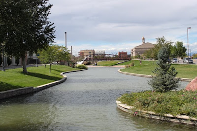
We arrived in Pueblo and stayed at Lake Pueblo State Park. The lake was created in the 1960's after repeated flooding in the Pueblo valley. A dam on the Arkansas River was built to control the water so it would pass the city through an aqueduct. Years later a revitalization project to incorporate the history of the river was begun in downtown Pueblo. The waterfront walk below is part of that project.
 |
| Sculptures and artwork accent the area. |
 |
| A closeup of one of the artwork pieces. |
While staying at the campground we took the pups on several hiking trails in the area and saw some stark but stunning terrain.
 |
| Lake Pueblo from the hills. The dam is on the right. |
 |
| Another picture of the lake from a distance. |
 |
| A burst of color in the rocks. |
 |
| The rock is layers of slate. We hiked down a ravine over layers of broken slate and it sounded like we were walking on glass. |
 |
| Pueblo's version of Stonehenge - that's what they named the trail. |
 |
| Plants struggle to survive in this climate unless they are succulents. |
We drove an hour over to Canon City to see the Royal Gorge. The gorge has a width of 50 feet at the base and several hundred feet at its top. It is a 10 mile long canyon running through the granite of Fremont Peak. According to scientists, the path of the Arkansas River was already set when the granite uplift that would eventually form the Rocky Mountains began. Approximately 3 million years ago, as the mountains began to rise from the surrounding plains, the Arkansas River started to wear away the stone as the water flowed across it. The mountains surrounding the canyon rose at a rate of approximately one foot every 2500 years. Over time, the small stream grew by cutting a deep channel through the surrounding granite. The gorge's long, narrow shape can be attributed to this erosion through hard rock.
 |
| The Royal Gorge is 1,053 feet deep. |
 |
| The Arkansas River running through the gorge. |
 |
| The granite rock is colored in different hues of pink. |
 |
| Another majestic view. |
 |
| The 'floor' of the bridge is made of wooden timbers. It's a scary feeling when a car or trolley drives past and you can feel the vibration underfoot while you are walking over it. |
 |
| While there we saw this white bison...... |
 |
| and an itchy elk.......... |
 |
| and mountain goats. |
See, we finally got you some pictures of the native wildlife! Next we are heading down to Santa Fe or should I say up since the elevation is higher there than in Pueblo. Peace to all!
For our trivia buffs:
How did Pike's Peak get it's name?
Captain Zebulon Pike was ordered to lead an exploratory expedition of the southwestern part of the Louisiana Territory to find the headwaters of the Arkansas and Red rivers. In 1806, Pike and his team recorded the sighting of the peak and tried to climb the summit. Unprepared for the conditions they made it as far as Mt Rosa to the southeast of the peak and gave up the ascent in waist-deep snow. In 1810, Pike wrote an account of his expeditions that was so popular it was translated into French, German, and Dutch for European publication. Zebulon Pike rose to the rank of brigadier general in the Army and later died at the Battle of York at the age of 34.


No comments:
Post a Comment