|
| A missile sitting on the side of the road near the White Sands Missile Range. |
 |
| Heading down into the valley toward Las Cruces. |
 |
| Another humorous billboard spotted from the interstate. Hey, what does a Beagle know? |
 |
| Miles of pecan trees. The Captain read about a rancher in the area who owns 128,000 trees. What a harvest that would be. |
 |
| Native American artwork along the interstate in New Mexico. |
We drove up to Silver City with an elevation of nearly 6,000 feet to view several of the local sights. The first one was the City of Rocks which consists of huge rocks that actually look like a city. The rocks were blown here 35 million years ago by a volcano 180 miles to the north. No one is sure why the rocks landed here and nowhere else.
 |
| Scientists believe this volcanic event may have lasted several years and was probably 1000 times larger than the eruption of Mount St. Helens. During the eruption the landscape was blanketed by layers of hot ash and pumice. |
 |
| The rocks, over time, have weathered to sculpture-like views. This one looks like a buddha. |
 |
| We viewed this as a positive indication, like Duke is number 1 ! |
 |
The City of Rocks is a state park and allows RVers to camp here. All around the 'city' were sites to park your rig if it wasn't too large.
|
 |
You were also allowed to climb all over the rocks to see the different areas. The complete 'city' takes up 1,230 acres.
|
 |
| Some of the streets were a little narrow. |
 |
| As the blanket of hot ash cooled it shrank slightly leaving vertical cracks. Over time, those cracks widened through weathering and erosion. |
 |
| After awhile you did feel like you were walking through an old city. |
 |
| In the Visitor Center they had several displays and I think this description says it all. |
Sixty-five miles north of Silver City is a place called 'The Catwalk' in the Gila National Forest. It is a mile log path made of scaffolding-like steel that hugs the rocky sides of the Whitewater Canyon. The Catwalk dates back to 1889, built by miners laying a three mile long pipeline to deliver water to a mill and temporary mining town.
 |
| The pups were very nervous walking on the catwalk, at least the part of it we were able to walk on. |
 |
| Unfortunately, a flood washed out several sections of it and it is in the process of being rebuilt. |
 |
| So we walked the section that was open and enjoyed the area as best we could. |
 |
| The scenic New Mexico mountains. |
The most interesting part of our visit was to the Gila Cliff Dwellings. They are only 44 miles from where we were staying but the road signs advertising it all said to expect a two hour drive. They weren't kidding! The only way to get there is to drive up the Trail of the Mountain Spirits Scenic Byway. It was slow and arduous because of the sharp curves and dangerous drop-offs but we got some beautiful pictures of the Gila Wilderness.
 |
| The Mogollon Mountains. |
 |
| The Gila National Forest is 3.3 million acres of public forest and rangeland. Located between the Rocky Mountains and the deserts of Mexico, elevations range from 4,500 to 11,000 feet. In the lower areas are cactus and grasslands, but as you climb higher you will find spruce, ponderosa, cottonwood and aspen trees. |
 |
| The ridge of sandstone cliffs in the center where the dwellings are. |
 |
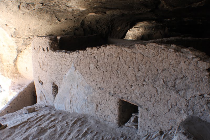
The people who built the cliff dwellings were part of the Mogollon culture. They were hunters and farmers and traditionally built pit houses or pueblos in the mountainous areas of Arizona and New Mexico. Breaking with tradition, the Tularosa Mogollon built inside the caves of Cliff Dweller Canyon with rock, mortar, and timbers cut between 1276 and 1287. Within 25 years they had moved on.
|
 |
| The one mile loop trail to and through the cliff dwellings climbs 180 feet above the canyon floor. At the dwellings you were met by volunteers who walked you through the rooms and described what scientists believe each was used for. |
 |
| This cave has three small storage areas and evidence for a larger central room that was likely home for one family. |
 |
| The dwellings had walls made of sandstone mortar and ceilings from timber. The rooms were built to allow the sun to heat them in winter and keep them cool in the summer. |
 |
| Special windows were built into the walls shaped like the letter T which is similar to Pueblo buildings. |
 |
| A closeup of a header used over one of the windows. |
 |
| At the upper part of the masonry wall are holes used to support the ceiling timbers. |
 |
| The black on the ceiling was soot from the fires used for cooking and heating. |
 |
| There were stairs in the dwelling leading to another story. |
 |
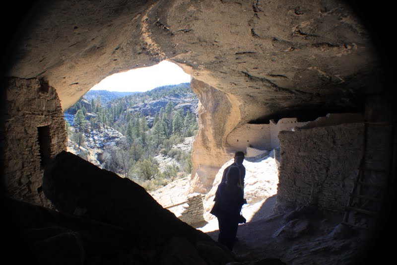
| A view of the canyon from inside the dwelling. |
 |
| Scientists believe this room may have been used as a communal area for ceremonial purposes. The people could use the steps to sit on. |
 |
| A close-up of the mortar they used. In places you could faintly see handprints where the mortar was patted on. |
 |
The dwellings were first written about in 1884. The writings revealed that vandals and relic-seekers had broken down walls, burned down roofs, and removed artifacts. As a result, it is impossible to know the specific use for each room. The vandals even carved their names into the walls and those carvings are now preserved as part of the past.
|
 |
| The small dips in the stone were used for grinding foodstuffs. |
 |
| Looking down into one of the rooms. |
 |
| One of the volunteers who was very helpful. She and her husband are RVers from Montana who spend the winter down in New Mexico. They stay in an RV park about eight miles from the site. |
 |
| A large living area. |
 |
| This is believed to be an oven at the top and the lower section with the 'door' used for storing meats. |
 |
| They even used vertical wall studs. |
 |
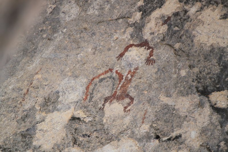
Ancient pictographs.

|
 |
| Walking along the side of the cliff to view the rooms. |
 |
| Several rooms in the dwelling were never completed. Scientists do not know why they abandoned the cliffs after only 25 years. They believe they may have met up with the Pueblo Indians and migrated up to the Santa Fe area. |
 |
The men were hunters and farmers. The women cooked and cared for the children. When water was needed the women had to climb down the side of the cliff to the Gila River below and haul it back up. All the adults helped in the building of the rooms.
|
 |
| A view looking up at the dwelling from the trail below. The cliff dwellers didn't have a trail to follow, they just climbed up the side of the mountain. |
 |
| From above, a view of the visitors center and the parking lot. |
Silver City is a good sized town in New Mexico that was once a silver mining town. It is also the home of Western New Mexico University.
 |
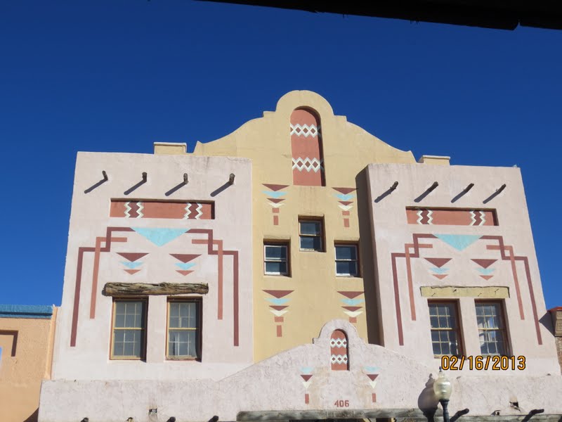
| It also has an historical district so we took a drive down there. |
' |
| The area where the town was first built was flooded twice so the city fathers moved the streets back and in the center of town is the "Big Ditch" which is a gulch 20-30 feet deep. |
 |
| Billy the Kid lived in a small log house at this location for a few years with his mother, his brother, and his stepfather. |
 |
| It had only one room for all of them. |
 |
| Many of the historic buildings had beautiful murals painted on them. |
 |
| And southwestern facades with |
 |
| window murals. |
We enjoyed our stay in Silver City and all the sights and finally headed to our next stop in Tucson, Arizona. Maybe it will be a little warmer there. Peace!