Wednesday, October 19, 2011

San Antonio, Texas

We arrived in San Antonio and it was Hot! Hot! Hot!   In fact, all of the places we stayed in Texas have been hot.  Normally, the temperatures are in the 80's this time of year but while we were here it hit 100 each day.  Needless to say, you didn't spend much time outside unless it was early in the morning.


Arriving in the city.


Our greeter at the RV park.  Only in Texas!
 We didn't do a great deal here but we did get down to the famous San Antonio Riverwalk and also the Alamo which was two blocks away from the walk in the heart of the city.  The Alamo in 1836 occupied the grounds and buildings of the former Mission San Antonio de Valero.  The mission had served as home to missionaries and their Indian converts for seventy years.  It was one of five missions that had once been along the San Antonio River until the Spanish officials secularized them and distributed the lands to the remaining Indian residents.  The actual remaining fortress is quite small.  You are not allowed to take any pictures or use your cell phone within the building compound because they are trying to preserve the remaining walls and interior of the buildings.  However, you were allowed to purchase as much information or other sundry items as you wanted within the enormous gift shop that was also housed within the fortress walls! 

The main entrance into the Alamo.


Inside the courtyard to view the remaining buildings.

Another view of the Alamo within the courtyard.


There were many magnificent old trees within the fortress walls.

The day we went to downtown San Antonio we were able to take a bus that stopped in front of the RV park we were staying in.  The RV park is five miles from downtown San Antonio and is right on the San Antonio River.   The city has decided to expand the Riverwalk an additional eight miles and part of that work was being completed where we were staying.  Besides the downtown tourist area,  the other section of the Riverwalk is used for hiking, biking, and jogging.  Years ago the city had problems with flooding so an aqueduct was built to control the water but it messed up the natural ecological effects of the river.  San Antonio has been correcting that problem and the Riverwalk today has many bends and turns in it designed to emulate the way it ran naturally years ago.  To each side of the river there are deep banks that have plantings that are indigenous to the region. Birds and fish have returned to their natural habitat and seem to be thriving.  The third phase to the Riverwalk should be finished by the end of 2012 and there will be parks and sports facilities built along with it so it will be very functional for the residents of the city.  

The downtown Riverwalk is below the main streets of San Antonio and it is 10-15 degrees cooler as soon as you get down the steps.  The area is beautiful and quite a place to see. 


One of the downtown entrances to the Riverwalk.  You walk down about 15 feet below the main street to get to the Riverwalk.  These steps were inlaid with tiles.


The Riverwalk has lush foliage and trees and neat bridges to get from one side to another. 


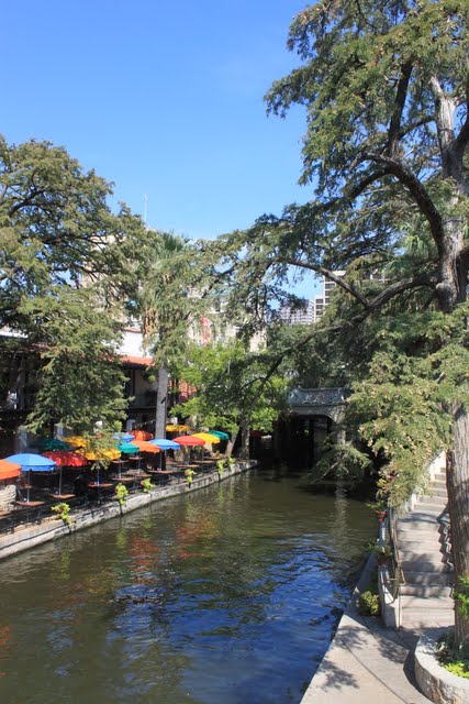
There are many restaurants and stores within easy access.


You can eat outside and watch the boats take tourists for a ride on the river.


We stopped for lunch and decided to eat outside.  There were many birds who inhabit the area and they sit at empty tables or in trees waiting for people to finish eating.  Once the diners leave, the birds race to the table and the ground below it looking for crumbs.  This bird was sitting across from us waiting for us to finish.


And so was his big brother!


Another view of the Riverwalk and the city above and behind it.


This has got to be a fun place in the evenings and weekends when people are through working.

While in San Antonio we visited two other missions.  The first was the Mission Concepcion.


The mission from a distance.


Murals on the walls when the mission was first built.


This church is still active with services each week.


The ceiling in the mission.


The outside structure made of local limestone.


Over the years experts have worked to restore the original artwork.

 The second mission we visited was Mission San Jose.  It is no longer active but is a good example of the compound where the missionaries and Native American Indians worked and lived.


The mission from a distance.  It was a good sized compound.


This is the main area behind the church where the missionaries lived.


Along the outer walls of the mission complex rooms were built where the Native Americans lived.

The church of Mission San Jose.


This is only a small piece of the original stucco that was on the buildings.  The colors must have been beautiful.


This was a mill they used to grind corn.  They built an aqueduct to bring in the water to turn the wheel.  


The inside of the mill.


The aqueduct is still in place today.


What is left of the main entrance to the church.
 
The area they used as a classroom to teach the Native Americans.


Another section of the mission.  Note the earthen roof with cactus growing on it.


Inside the mission compound are beautiful old live oak trees.

We left San Antonio and headed to Niceville, FL, to see our younger daughter and family.  From there we headed to a Tiffin rally in Pine Mountain, GA, and now we have arrived home.  We will be staying here (off and on) for a few months until January when we head out on the trail for a three month adventure along the Florida coast.  One of our goals is to have a margarita and a 'cheeseburger in paradise' at Jimmy Buffett's restaurant in the Florida Keys.

Hope you all have a wonderful fall and holiday season and we will continue this blog in 2012.  Peace to all.

For our trivia buffs:
How did the state of Texas get its name?

Its name comes from the Caddo tribe and the Spaniards.  During the Spanish exploration of Texas in the 1540s, the Spaniards met the Hasnai Caddo tribe in present-day East Texas. The Native Americans used the word tayshas for "friends" or "allies." In Spanish, the translation came out as tejas. Eventually, Tejas became Texas.


Tuesday, September 27, 2011

Albuquerque, New Mexico

Albuquerque is the largest city in New Mexico and over seven times the size of Santa Fe, the capital.  It sprawls in a valley with the Sandia Mountains along the eastern side and the Rio Grande River flowing through the city, north to south.  The city is situated in a basin which is part of the Rio Grande Rift, a north trending continental rift zone from Colorado into Mexico.  A rift is a thinning in the Earth's surface caused by stretching the surface through geological stress.

Some rifts form basins such as the Rio Grande that over millions of years fill with sediment. At Albuquerque, the basin sediments are three miles deep. The rift continues to widen today, although very slowly, 0.5 to 2 millimeters per year, and as it widens the mountains become taller and the valley sinks lower. 


A view of Albuquerque from the mountains.  The big chunk of dirt on the right is the Rift in the Rio Grande Basin.

Since we had so much fun hiking in Santa Fe, we decided to do even more in Albuquerque.  Our first stop is locally known as the Albuquerque Volcanoes or the Three Sisters.  Instead of the 'magma' rising through a vertical central vent as most volcanoes do,  these volcanoes are a rare example of a fissure eruption that is over five miles long and resulted in a row of aligned craters.  


View of the three volcanoes from a distance.

Max is king of the hill on a bed of lava.

Reminds me of something on another planet.

Albuquerque is in the distance.  The volcanoes are 250 feet high.


On our second day we decided to climb Sandia Crest in the Sandia Mountain Range of the Cibola National Forest.  What a cool place......literally.....it is 20 degrees cooler in the mountains than down in Albuquerque.  The first day we hiked it was only 55 degrees.   


Changing colors in the mountains.  Fall really is coming.....honest!
 
Our hike was 3.25 miles with an elevation gain of 625 feet.  That's because you are starting at 10,000 feet when you begin the climb.  It was an easier trail that offered beautiful views of the city and surrounding mountains


Climbing the Sandia Mountains.


Albuquerque from the Sandia Peak.

Another view of the very large city.  We were at the 10,678 foot level.


You can ride a cable car from the city up to the top of the Sandia Crest.  It is the world's second longest tramway, 2.7 miles ascending over 4,000 feet.  There is a nice restaurant and bar at the top.  Along the other side of the crest there is a ski slope in the winter and the ski lift also accesses the restaurant.   


What a view.


In some areas the wild flowers were still in bloom in meadows between the tree lines.

We had such a great time we decided to hike the mountains again.  The next day was a Saturday so there were more people using the trails.  The trail we took on this day was called the 10k trail because it ran along the 10,000 foot elevation level.  From where the trailhead started we descended a good distance before the trail changed and we climbed upward 1410 feet and covered 6.5 miles.  Yes, we are gluttons for punishment!   There were a lot of other people getting ready to hike at the same area we were in and most of them had their dogs along.  Surprisingly, throughout the whole hike we only met two other people on the trail and never ran into any of the other dogs.   
 

Lots of rocks and trees.


The stones on the path were shiny from the effect of weather and the many previous hikers who used trail.


Fallen trees was a common theme throughout the walk.  The wind and elements are very powerful near the top.


I love this picture.  Millions and millions of Aspens.


It was a gorgeous hike.


Another mountain view.

We were exhausted.  I went through my gasping routine several times before we got to the top.  Even the dogs were wasted but we still had a good time.  Of course, knowing we were heading south the next day also relieved us of the thought that we would be doing it again soon.  But we plan on being back next year because they have many other trails we haven't explored yet.

The RV park we stayed at provides picnic tables to the residents.  Thought you might like to see this one.  Since Albuquerque is in the valley it is hotter and extremely dry.  The soil is cracked and there is little moisture or plants unless you use tons of water.  We like the mountains much better than the city.


Would you want to plop your butt on that ???


Next stop is San Antonio, Texas.  Peace to all!


For our trivia buffs:
The population of Albuquerque is growing rapidly and is expected to hit 2 million by 2030.  The city, however, only receives 6 to 9 inches of rain each year and is considered an arid climate.  Where do they get their water from?

Fifteen thousand feet of water-deposited sand and mud now fill the basin underneath the city.  Most of Albuquerque's water is trapped in the pore spaces of this sediment.