Tuesday, September 27, 2011

Albuquerque, New Mexico

Albuquerque is the largest city in New Mexico and over seven times the size of Santa Fe, the capital.  It sprawls in a valley with the Sandia Mountains along the eastern side and the Rio Grande River flowing through the city, north to south.  The city is situated in a basin which is part of the Rio Grande Rift, a north trending continental rift zone from Colorado into Mexico.  A rift is a thinning in the Earth's surface caused by stretching the surface through geological stress.

Some rifts form basins such as the Rio Grande that over millions of years fill with sediment. At Albuquerque, the basin sediments are three miles deep. The rift continues to widen today, although very slowly, 0.5 to 2 millimeters per year, and as it widens the mountains become taller and the valley sinks lower. 


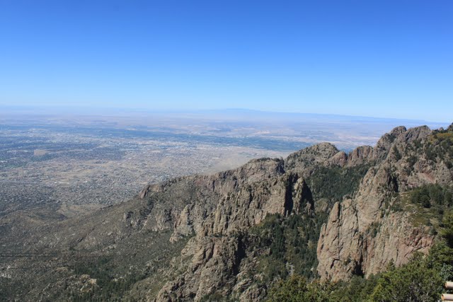
A view of Albuquerque from the mountains.  The big chunk of dirt on the right is the Rift in the Rio Grande Basin.

Since we had so much fun hiking in Santa Fe, we decided to do even more in Albuquerque.  Our first stop is locally known as the Albuquerque Volcanoes or the Three Sisters.  Instead of the 'magma' rising through a vertical central vent as most volcanoes do,  these volcanoes are a rare example of a fissure eruption that is over five miles long and resulted in a row of aligned craters.  


View of the three volcanoes from a distance.

Max is king of the hill on a bed of lava.

Reminds me of something on another planet.

Albuquerque is in the distance.  The volcanoes are 250 feet high.


On our second day we decided to climb Sandia Crest in the Sandia Mountain Range of the Cibola National Forest.  What a cool place......literally.....it is 20 degrees cooler in the mountains than down in Albuquerque.  The first day we hiked it was only 55 degrees.   


Changing colors in the mountains.  Fall really is coming.....honest!
 
Our hike was 3.25 miles with an elevation gain of 625 feet.  That's because you are starting at 10,000 feet when you begin the climb.  It was an easier trail that offered beautiful views of the city and surrounding mountains


Climbing the Sandia Mountains.


Albuquerque from the Sandia Peak.

Another view of the very large city.  We were at the 10,678 foot level.


You can ride a cable car from the city up to the top of the Sandia Crest.  It is the world's second longest tramway, 2.7 miles ascending over 4,000 feet.  There is a nice restaurant and bar at the top.  Along the other side of the crest there is a ski slope in the winter and the ski lift also accesses the restaurant.   


What a view.


In some areas the wild flowers were still in bloom in meadows between the tree lines.

We had such a great time we decided to hike the mountains again.  The next day was a Saturday so there were more people using the trails.  The trail we took on this day was called the 10k trail because it ran along the 10,000 foot elevation level.  From where the trailhead started we descended a good distance before the trail changed and we climbed upward 1410 feet and covered 6.5 miles.  Yes, we are gluttons for punishment!   There were a lot of other people getting ready to hike at the same area we were in and most of them had their dogs along.  Surprisingly, throughout the whole hike we only met two other people on the trail and never ran into any of the other dogs.   
 

Lots of rocks and trees.


The stones on the path were shiny from the effect of weather and the many previous hikers who used trail.


Fallen trees was a common theme throughout the walk.  The wind and elements are very powerful near the top.


I love this picture.  Millions and millions of Aspens.


It was a gorgeous hike.


Another mountain view.

We were exhausted.  I went through my gasping routine several times before we got to the top.  Even the dogs were wasted but we still had a good time.  Of course, knowing we were heading south the next day also relieved us of the thought that we would be doing it again soon.  But we plan on being back next year because they have many other trails we haven't explored yet.

The RV park we stayed at provides picnic tables to the residents.  Thought you might like to see this one.  Since Albuquerque is in the valley it is hotter and extremely dry.  The soil is cracked and there is little moisture or plants unless you use tons of water.  We like the mountains much better than the city.


Would you want to plop your butt on that ???


Next stop is San Antonio, Texas.  Peace to all!


For our trivia buffs:
The population of Albuquerque is growing rapidly and is expected to hit 2 million by 2030.  The city, however, only receives 6 to 9 inches of rain each year and is considered an arid climate.  Where do they get their water from?

Fifteen thousand feet of water-deposited sand and mud now fill the basin underneath the city.  Most of Albuquerque's water is trapped in the pore spaces of this sediment.


Sunday, September 25, 2011

Santa Fe, New Mexico

We left Pueblo heading to Santa Fe, New Mexico,with an elevation of 7,000 feet.  On the drive up we snapped some pictures:


Entering New Mexico - this area must have had a fire a few years back because all the trees are burned.


Climbing up in elevation - lots of greenery in the mountains.


Along with mountains we also see mesas.
 
Santa Fe in the background.  Most of the buildings are adobe.


Santa Fe is the capital of New Mexico.  The buildings and homes are mostly adobe and usually not more than two stories high, even in the downtown area.  In the early 1900's, the city embraced the Pueblo Revival style to reflect the architecture of the Pueblo Indians.  Today you can easily see the mountains from anywhere in the city and the adobe style is a great representation of the southwest.  Once settled in, we decided to visit the Old Town part of Santa Fe which is the tourist area.  It has some beautiful old churches, many, many shops, and a street cordoned off to allow local artisans to display and sell their ware.  While there we checked for a restaurant that had authentic Mexican food.  We were told to go to The Shed.  The entrance way was a small door that led into a large patio area with several shops and the restaurant accessing it.  We ate outside in the patio and had enchiladas with chili sauce and pinto beans and posole (a type of dried corn cooked with pork and other ingredients).  It was delicious!  They also served beer from the local brewery that we just had to try, too.


The award winning Shed
The Shed - this is the place!

San Miquel Church - oldest church structure in the United States, circa 1610.


There were many expensive art studios with their work displayed outside.  These works were carved from wood.

Old Town Santa Fe.


Cathedral Basilica of Saint Francis Assisi.
  T
Another neat place called  the Rainbow Shoppe.


The closed off street with the vendors.  Most were Native American Indians.  Brett looked at a small piece of hand designed pottery that was only selling for $500.  He didn't buy it.  
 

Sculpture of sleeping bears made from wood.

 We decided to go hiking the next day and found a trail head in the Atalaya Mountains.  The area is close to downtown Santa Fe and many people use it for exercise.  We started our hike at approximately 7,000 feet and decided to climb Picacho Peak with the pups.  The trail is a series of switchbacks that climbs to over 9,000 feet.  Along the way we met people who were also hiking with their dogs, people who were climbing it during their lunch break, and several really buff guys (very young, I might add) who were running up the mountain.

We hiked at a reasonable (doctor approved) pace because we didn't want to show anybody up.  The first hour wasn't too bad......even saw a lizard.......and the weather was comfortable with shade from the trees keeping us cool on the path.  Did I say path?  It was maybe a foot wide and much of the time it was climbing over a series of rocks that represented the trail.  Now how can you run on that!  The trail was marked at junctures which  showed different climbing areas of the mountains but it was confusing so you had to be careful to not get lost.

The second hour was more aggressive hiking because the trail was much steeper.   With a higher elevation there was less oxygen so our hearts were really pumping.  I won't even mention that most of the people who passed us going up were now coming down!  We continued on with me having to stop every few minutes to gasp some air.  I am proud to say we made it to the top and took some wonderful pictures of the Santa Fe Valley to share with you. 

It took us two hours to climb up and I won't even mention that we got lost on the way down, which took another hour and a half.  Yes, we took the wrong juncture and wound up doing some extra hiking but finally made it back to the car.

 
Climbing the Atalaya Mountains.
 
Our little lizard friend.  Can you see him?


View of the Santa Fe Valley from Picacho Peak.


Another view of the city from the top.


The 'mountain man' at 9,121 feet.


Wild flowers high up in the mountains.
Next we are heading down to Albuquerque which is 60 miles down the road.  I hear they have some wonderful hiking trails. too.  Hmmmm......        Peace to all.

For our trivia buffs:
The city of Santa Fe has been around for over 400 years and is the state capital.  But how long has New Mexico been a state?
New Mexico  was accepted as the 47th state in 1912.  This coming year they are celebrating their centennial anniversary and have already redesigned their vehicle license plates to reflect the occasion.


Wednesday, September 21, 2011

Heading to Pueblo, CO, and the Royal Gorge


We spent several more days with family in Helena and then headed south for Pueblo, CO.  Here are some photos we took along the way.


Canyon Ferry Lake, MT


Southeastern Montana early morning.


Leaving Montana

Our hosts at our first night stop, the 7th Ranch RV Park in Gerryowen, Montana.  They were' neigh'borly!


Entering Wyoming.  The roads are pink because they use local slate for the highways.


The Bighorn Mountain Range in Wyoming.


Low lying clouds over the range.


Pronghorn antelope feasting in a farmer's field.


Coming into Casper, Wyoming.


After Casper mostly desolation.


Driving into Denver, Colorado.


Mile High Stadium.


All the sound barriers along the interstate had different patterns sketched into the stone. 


Castle Rock, Colorado.


The clouds and the mountains merge.


Pike's Peak from Colorado Springs.  It already has snow.


One of my favorite pictures.  Awesome!


Storms rolling in along the way.


Lake Pueblo State Park.  Totally different terrain.

We arrived in Pueblo and stayed at Lake Pueblo State Park.  The lake was created in the 1960's after repeated flooding in the Pueblo valley. A dam on the Arkansas River was built to control the water so it would pass the city through an aqueduct.  Years later a revitalization project to incorporate the history of the river was begun in downtown Pueblo.  The waterfront walk below is part of that project.  


Part of the downtown riverwalk.


 Many businesses are situated alongside the riverwalk and employees sit outside during lunchtime.


Sculptures and artwork accent the area.


A closeup of one of the artwork pieces.

While staying at the campground we took the pups on several hiking trails in the area and saw some stark but stunning terrain.


Lake Pueblo from the hills. The dam is on the right. 


Another picture of the lake from a distance.

A burst of color in the rocks.


The rock is layers of slate. We hiked down a ravine over layers of broken slate and it sounded like we were walking on glass.


Pueblo's version of Stonehenge - that's what they named the trail.


Plants struggle to survive in this climate unless they are succulents.

We drove an hour over to Canon City to see the Royal Gorge.  The gorge has a width of 50 feet at the base and several hundred feet at its top.  It is a 10 mile long canyon running through the granite of Fremont Peak.  According to scientists, the path of the Arkansas River was already set when the granite uplift that would eventually form the Rocky Mountains began. Approximately 3 million years ago, as the mountains began to rise from the surrounding plains, the Arkansas River started to wear away the stone as the water flowed across it.  The mountains surrounding the canyon rose at a rate of approximately one foot every 2500 years. Over time, the small stream grew by cutting a deep channel through the surrounding granite. The gorge's long, narrow shape can be attributed to this erosion through hard rock.


The  Royal Gorge is 1,053 feet deep.


The Arkansas River running through the gorge.


The granite rock is colored in different hues of pink.


Another majestic view.


The suspension bridge was built in 1929 by the people of Canon City.  It was listed as the world's highest suspension bridge, at that time.  The work began in June and was completed in November at a cost of $350,000.  


The 'floor' of the bridge is made of wooden timbers.  It's a scary feeling when a car or trolley drives past and you can feel the vibration underfoot while you are walking over it.


While there we saw this white bison......


and an itchy elk..........


and mountain goats.

See, we finally got you some pictures of the native wildlife!  Next we are heading down to Santa Fe or should I say up since the elevation is higher there than in Pueblo.  Peace to all!

For our trivia buffs:
How did Pike's Peak get it's name?

Captain Zebulon Pike was ordered to lead an exploratory expedition of the southwestern part of the Louisiana Territory to find the headwaters of the Arkansas and Red rivers.  In 1806, Pike and his team recorded the sighting of the peak and tried to climb the summit.  Unprepared for the conditions they made it as far as Mt Rosa to the southeast of the peak and gave up the ascent in waist-deep snow.  In 1810, Pike wrote an account of his expeditions that was so popular it was translated into French, German, and Dutch for European publication.  Zebulon Pike rose to the rank of brigadier general in the Army and later died at the Battle of York at the age of 34.