|
| The Monitor and the Merrimac |
We arrived in Moab, Utah, to 100 degree heat and very little shade. Checking the weather forecast we realized that the heat would remain for our full week stay so we had to adjust. We went to a lot of state and federal parks so we could see as much of the sights as possible. Being early risers, we were in the parks usually by 7:00 AM when the weather was much cooler and the crowds were non-existent. We had a wonderful time here and tried to capture as much beauty as we could to share with you.
 |
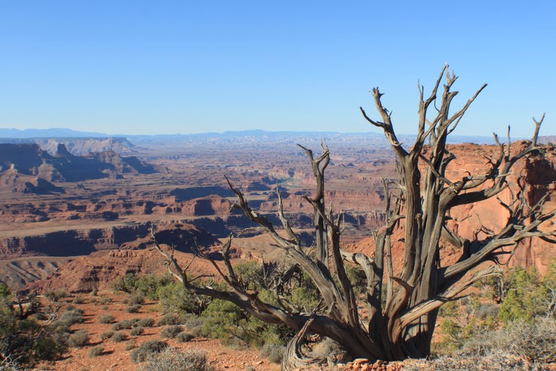
| Dead Horse Point State Park was our first stop and the panorama was breath-taking. The rock formations were created over 275 million years ago and the changes in the strata can be seen in the history of the rock from what they call the Rico formation to the Navajo sandstone. |
 |
| A view of the Colorado River working its way through the stone. |
 |
| The vastness and isolation is amazing. |
 |
| Another view. |
 |
| The little pile of rocks on the left are called cairns. They are used to mark the trail as you hike through the park. Sometimes the cairns are difficult to see and you can become lost especially if you are hiking over large rock formations. We know. |
 |
| This looks like an ancient castle. |
 |
| A view of the rock strata and the changes in the composition caused by floods or wind over millions of years. |
 |
| Quoth the raven, "Nevermore." |
 |
| We thought this formation looked like a tortoise. |
The second morning we went to Arches National Park. The park lies atop an underground salt bed that is responsible for the arches, spires, and sandstone monoliths. The salt bed was deposited across the Colorado Plateau 300 million years ago when a sea flowed into the region and eventually evaporated.
 |
| Tall spires. |
 |
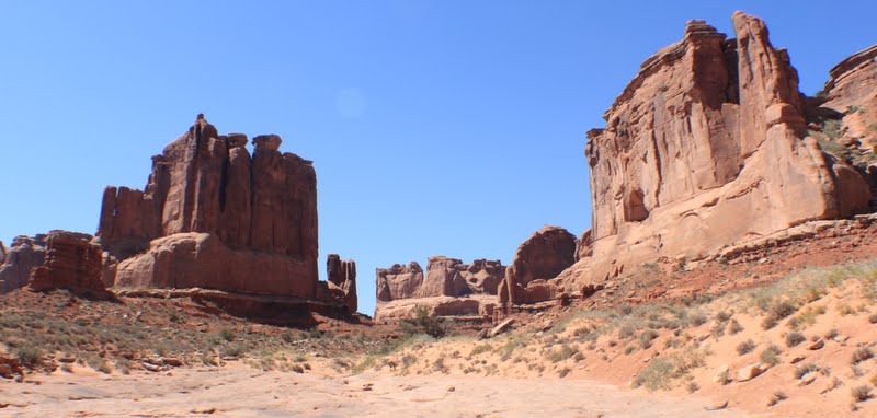
| The Courthouse Towers. |
 |
| A view of the Petrified Dunes. Over 200 million years ago winds carried tons of fine grained sand into the area creating an immense desert. Over time, the sand drifts were covered by other layers of sediment, compressed,and cemented by quartz and calcite into Navajo Sandstone. Erosion has since washed away the overlaying layers exposing the petrified dunes. |
 |
| This is Balanced Rock. The capstone rock is made of hard Slick Rock which is perched upon a pedestal of mudstone. This softer rock weathers more quickly than the rock above which will eventually lead to the collapse of the Balanced Rock. |
 |
| The total height is 128 feet. including the boulder and weighs 3,500 tons. |
 |
| The back side of the Balanced Rock. You can see how delicate it is. |
 |
| A wide angle view of the Arches. |
 |
| Notice the guy second from the left..........kind of looks like an alien.........I think he was watching us....... |
The next morning we drove back to Arches to film the sunrise. It was magnificent.
 |
| A silhouette of the Balanced Rock. |
 |
| Such a vast area. |
 |
| Walls were flooded in orange tones. |
Another attraction in the Arches National Park is the Delicate Arch. It is a long hike to get to it and we were glad we went early in the morning. As we were coming back down around 10:00 there was a migration of tourists heading up to the arch and they were already hot and uncomfortable. The park recommends you carry at least a quart of drinking water for each person if you are hiking because of the intense heat. Many of these people did not have back packs or even proper walking shoes.
 |
| Heading up the path toward the Delicate Arch. |
 |
| The beginning of another arch..........maybe in a few million years. |
 |
| A baby arch. |
 |
| The Delicate Arch. It is aptly named because it is showing the wear and tear of the sun and wind. |
 |
| Another angle where you can see the arch wearing away. |
 |
| Just to give you an idea of the size, that is Brett standing in the middle of it. There were only 10 other people there when we arrived so it gave us the opportunity for great shots. |
We also hiked to the Landscape Arch and took these pictures along the way.
 |
| Seeing people on the trail shows how large these rocks are. |
 |
| The Landscape Arch has a 306 foot span. |
 |
| Notice the damage on the right side of the arch. A large piece weighing 110 tons broke off in 1991. A visitor was in the area at the time and photographed it as it broke. |
 |
| I think he is following us now............. |
 |
| Other arches in the park. You can see why it is named Arches National Park. This particular park is only a mile from Moab so it is heavily visited. There were many tourist buses and we heard languages from all over the world. |
 |
| These two arches are called the North and South Windows. |
 |
| Another trail took you around to the back side of the Windows. It was an interesting hike but very few people viewing the arches walked around them. |
 |
| This formation was named 'The Three Gossips'. |
 |
| Another trail in the park was called Park Avenue because the rocks look like skyscrapers. |
 |
| Is this Broadway in the future? |
 |
| We thought this looked like a giant thumb. |
 |
| It was interesting how some rock formations teetered on top of others. |
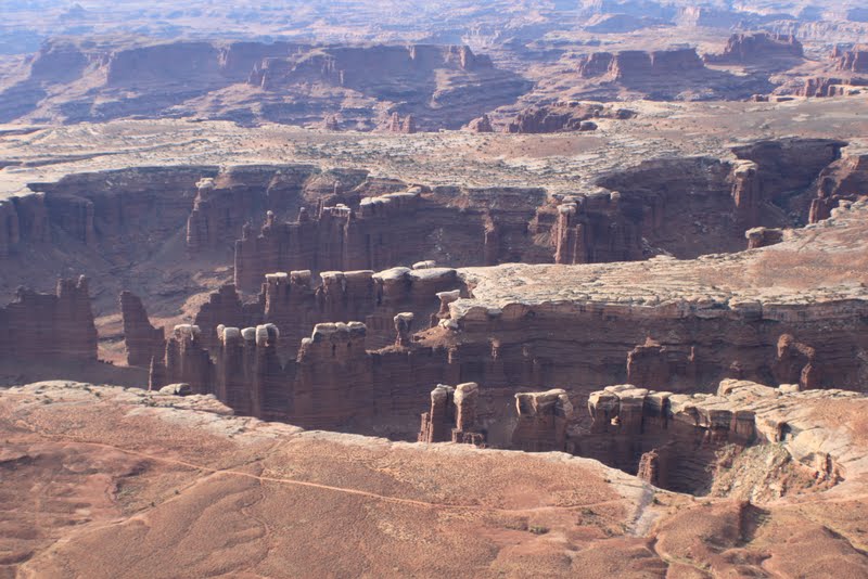
Another national park we visited is called Canyonlands. Water and gravity were the prime architects of this vast area cutting flat layers of sedimentary rock into hundreds of canyons, mesa, buttes, and spires. At center stage are two canyons carved by the Green and Colorado Rivers. The park is 527 square miles in area. It is so large that you have to drive to different entrances in order to see specific areas. Canyonlands remains largely uncontrolled with its roads mostly unpaved, trails primitive, and rivers free-flowing. It can be a very scary place.
 |
| Canyonlands National Park - Grand View Point Overlook. |
 |
| So remote and vast. |
 |
| Lots of spires. |
 |
| Amazing what wind and water can do. |
 |
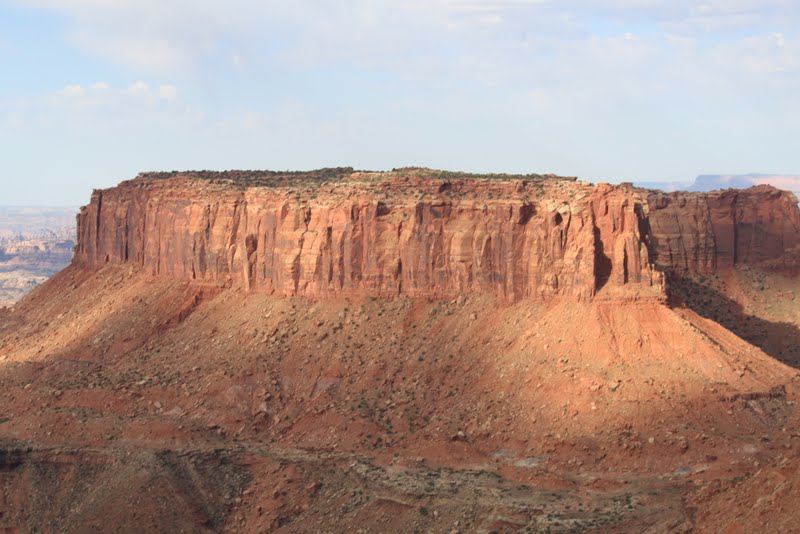
| A large mesa in the park. |
 |
| A very desolate view. |
 |
| We were on a trail up on a ledge and this rock was leaning over the side. |
 |
| Cracks where the rock is eroding. The process probably takes tens of thousands of years, |
 |
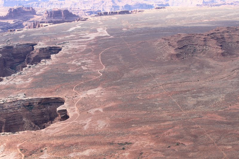
| See the lines below that look like trails. The left side near the rim is a road used today for ATVs. The straight road on the right was used when uranium was being mined. It hasn't been used in over 50 years but is still evident to the eye. |
 |
| The black crust beneath this plant is called cryptobiotic crust. It is a mixture of cyanobacteria, mosses, lichen, fungi, and algae. It is a living organism that holds the desert sands together, absorbs moisture, produces nutrients, and provides seedbeds for other plants to grow. The crust is so fragile that one footprint can wipe out years of growth which is why they ask everyone in the park to stay on the trails.. |
 |
| This is another view of the black crust. Without it, there would be no plants and few animals. |
 |
| Another awesome view. |
 |
| Buck Canyon Overlook. |
 |
| Upheaval Dome Overlook. Scientists are debating whether it was caused by a meteorite or an upheaval of the salt floor which left this dome when it collapsed. |
 |
| Or maybe it was how the aliens came here that were watching us throughout the parks. |
 |
| Green River Overlook. You can see the river twisting through the canyon. |
 |
| The Green River meets up and merges with the Colorado River further downstream. |
 |
| Mesa Arch in Canyonlands. |
While we were in Moab we drove to a section of Canyonlands called The Needles to view the sunset. The drive was a good hour from Moab before we got to the Needles entrance of the park. Then it was another 22 miles to the Needles Lookout Point. We were the only ones in this section of the park and it was very remote. Cell phones do not work out here. There was nothing but desert and rocks around us and it made me nervous. Even worse, after we took the pictures we had to drive back out in the dark and it was even scarier. Many of the animals had come out to feed. Birds and other critters were actually sitting on the road absorbing the heat from the asphalt as the temperature dropped. But the pictures were worth it!
We also looked for trails that were dog friendly and found a real jewel. It is called Negro Bill Canyon and was named after William Granstaff, a mixed race cowboy, who prospected and ran cattle in the desert canyon in the late 1870's.
 |
| Most of the trail ran along a stream that flows into the Colorado River watershed and the path was cool with trees on one side and canyon walls on the other. |
 |
| You had to cross the stream several times as you climbed up to the top of the canyon. |
 |
| This is called the Morning Glory Natural Bridge and it is the sixth longest natural rock span in the U.S. at 243 feet. |
 |
| We don't know what caused the black strata in the rock formation but it sure is beautiful. |
 |
| A little more beauty on the hike up. |
After the 4 mile hike to the Morning Glory Bridge we decided to take the pups on a rafting trip down the Colorado River. We drove up to a point where we could launch and inflate the boat. Then the pups and I waited while Brett drove four miles down the road and parked the SUV. After that he got on his bike and pedaled back up the highway to where we were patiently waiting to cast off. Lucky guy, hey! The boat trip down took over two hours and it got hot because the temperature was over 100 degrees. The dogs jumped in (or got pushed in) to keep them cool. We were both wearing T-shirts over our swimsuits so we dropped the shirts into the river to get them wet and then slipped them back on. Whoa!!! The air temperature may have been high but the water temperature wasn't. It cooled you off very nicely.
 |
| Paddling down the Colorado River. |
 |
| Is this the life or what???? |
 |
| Max pooped out on the boat trip. |
 |
| Lucy wasn't much more energetic. |
 |
| The scenic Colorado River. |
 |
| We weren't the only ones having fun. |
Since we enjoyed the sunset so much earlier in the week we decide to go back to Dead Horse Point State Park and have a picnic dinner with the pups.
 |
| Another stellar sunset. |
 |
| The clouds gave it a unique look. |
 |
| Dining on cheese, crackers, fruit, and chocolate. Oh yes, and some good, white wine. |
 |
| All is quiet with the world. |
On our last day in Moab we went to Fisher Towers Trail. Like Negro Bill Canyon Trail, it is controlled by the Bureau of Land Management and is a recreational area. The drive was approximately 21 miles and along the way, and in the park, we saw some unexpected sights.
 |
| As usual, we were out in the early AM and saw this hot air balloon alongside the highway with several tracking vehicles by it. |
 |
| Fisher Tower Trail was another beautiful place to hike but it was more arduous than others we had been on. |
 |
| The towers were intriguing. |
 |
| The colors were vibrant. |
 |
| You had to climb carefully. |
 |
| This was called a constructed trail.........I use the term loosely. |
 |
| Amazing rock formation or is this a space dog? |
 |
| On the trail you continued to climb up. |
 |
| We had trouble finding the cairns that marked the trail and we got lost twice. |
 |
| Coming around a corner we viewed the highest rock formation called 'The Titan' and Brett noticed a small blue spot on it. |
 |
| This is it up close. Rock climbers camped on the face. Now that takes courage. |
 |
| We weren't able to go much farther because there was a ladder that we couldn't get the dogs on. Just as well. On the way back Max got overheated and was seeking shelter in the shade. When we got off the trail we took both pups to the Colorado River so they could jump in and cool off. |
And that is it from Moab. The day we left the temperature was going to be 106. We loved the area but the heat and the dryness is hard to accept after spending years in South Carolina. So on we go to Redding, CA, and new adventures.
 |
| Peace to all. |