 |
| Mount Kerkeslin at 9,700 feet. |
 |
| The Athabasca River in the Canadian Rockies. |
 |
| The blue-green color is from the ice flow melt. |
We arrived at Jasper National Park and saw that it was much more rugged than Banff National Park. The camp sites were in circles with three circles per section which afforded you more space per unit but the amenities were less. There were many dead trees in the campground and the roads were rough and full of potholes. Bathroom facilities were minimal per circle and the electrical infrastructure was limited. While we were there we saw an announcement that Jasper National Park will be closed all of 2019 in order to do a total upgrade. We understand the necessity of doing it but many of the campers we met were from cities or provinces nearby and they loved coming to this park.
 |
| While in the park they warned us about the cow elk because it was calf season and the mommas could be very aggressive. |
 |
She doesn't look like she has a mean bone in her body. However, the morning we left the Jasper NP the Captain was walking the dogs around 6:00 A.M. and he and the pups saw a couple of cute young elk. They stood there and looked at them until the Captain heard a snorting noise and looked up to see a cow elk looking back. The momma elk snorted again, dropped her head, and started charging at them. The Captain grabbed the leashes, pulled the dogs around, and headed in another direction. Luckily, the cow elk stopped and joined her babies. It was all so quick there wasn't even time for a photo op. LOL.
|
 |
| The park was full of beautiful aspen trees but you could also see dead pine trees mixed in. |
 |
| Desi was blessed with another family of marmots in our space so he had a ball trying to catch one. Here he is digging in one of the marmot holes hoping he can find something. Not to be. |
 |
| We checked out the town of Jasper. |
 |
| The train station in Jasper for those who don't want to fly or drive. |
 |
| The weather was gorgeous and the town was hopping. |
 |
| Restaurants and outdoor cafes were plentiful. |
We stayed at Jasper National Park for several days and heard about a tram ride up Whistler's Mountain that has 360 degree views. We thought that would be fun so we hiked the pups in the morning and then went for he tram ride. We were smart enough to wear warm clothes believing it would be cold and windy. We also wore tennis shoes instead of hiking boots and we didn't take hiking sticks with us thinking it would only be a 30 minute photo-op. Big mistake!
 |
This is where the tram takes you up to on Whistler's Mountain. It is about a 7 minute ride.
 |
Our second bear sighting.
 |
 |
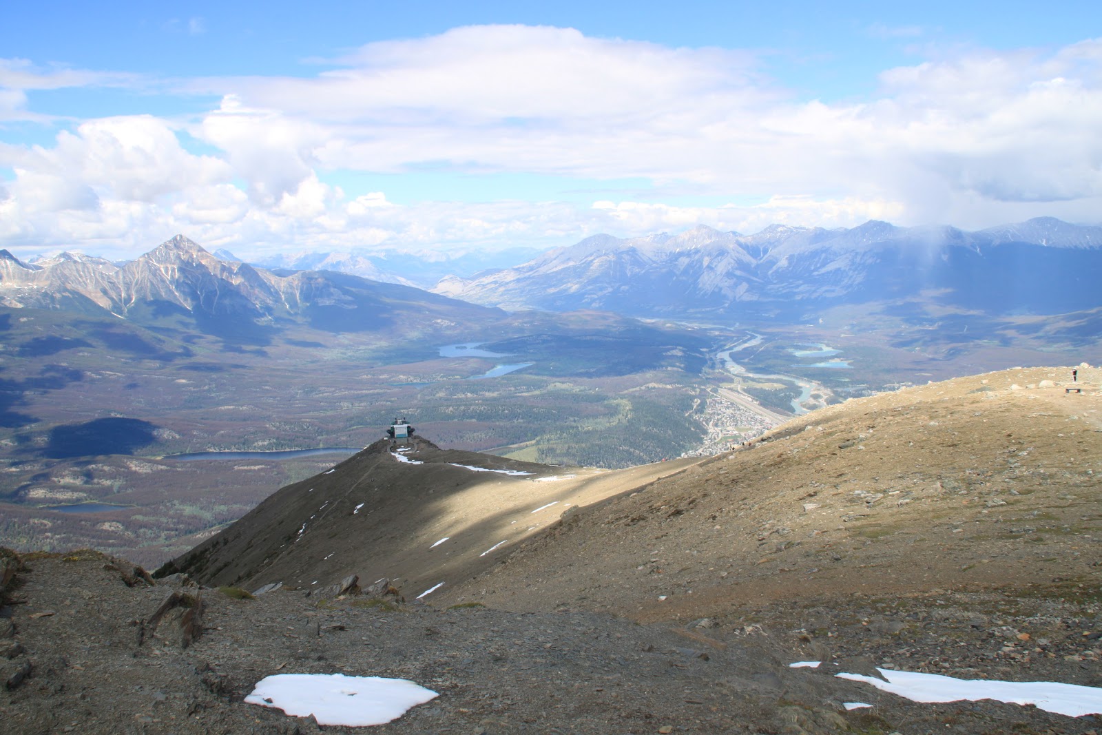
A view of Jasper as the tram climbed up the mountain.
Arriving at the platform we realized there was a hiking trail up to the top of Whistler's Mountain. It was a steep hike but we decided to go up. Along the way there were large rocks one could sit on to catch your breath. Many other people were also taking the hike including those is shorts and flip-flops. Go figure.
 |
| A view from the trail. |
 |
|
Below is a good view of the dying lodgepole pine tree that we have seen along our journey. The tree is being killed by a pine beetle and one of the guides with the tram said over 60 percent of this specie of pine tree has been killed. They predict in another year it will be over 90 percent which could be a major fire hazard in dry weather because the dead trees make forest fires very unpredictable.
Five years ago, when we were in Helena, Montana, we saw huge forests of trees that had died from the pine beetle. This year we didn't notice any at all. The trees were all infected and died and the forest fires burned them down.
Unfortunately the pine beetle kept spreading north and has now invaded Canada and threatens a major timber industry. It also has an effect on the ecology of the forests because the lodgepole pine serves a specific purpose in the forest. The only thing that can stop the pine beetle spread is having several days of negative 40 degree weather to kill the larvae but the weather doesn't get quite that cold this far north.
|
|

 |
Even at higher altitude the flowers were in bloom.
|
 |
| Two-thirds of the way up it was quite cool and windy and I was bundled up. |
 |
| We made it almost to the top except for the last section that was full of snow and quite slippery. |
 |
| Looking at how far down the tram stop is from where we were on Whistler's Mountain. |
 |
| More views of the beautiful Canadian Rockies. |
 |
| Felt like we were on top of the world. What a fantastic hike! |
 |
| The Captain enjoying the view near the top. |
The next day we took a great hike in Maligne Canyon in Jasper NP and the pups got to go along. Medicine Lake is like a giant leaky bathtub. It drains through an underground cave system resurfacing 10 miles downstream through springs along the Maligne Canyon. The water can take less than 12 hours during peak run-off times, or up to 88 hours during the winter to complete its underground journey. There are six bridges you can walk across to take photos of the canyon as the water flows through.
 |
| The canyon is quite deep and sometimes you can barely see the bottom. |
 |
| Notice the ice still on the side of the canyon wall. Because of the shade there isn't enough warmth to melt it. |
 |
| Water seeping into the canyon from the Medicine Lake. |
We also drove over to the Athabasca River to see the waterfalls. This river links the the Columbia icefield to the Pacific Ocean. After it leaves Jasper NP, the river gathers water from most of Alberta and flows through towns and farm lands making its way to the ocean.
 |
It was quite a view.
 |
| You had to walk down a series of steps to see the lower part of the river. This section used to be part of the canyon where the water flowed but due to natural changes in the water pattern this area was abandoned. |
T
|
 |
| Below the waterfall people were kayaking down a more placid part of the river. |
 |
| Saw another big boy coming back from our view of the falls. |
We left Jasper and headed northwest towards Grande Prairie with beautiful landscape along the way. The road was a two-lane highway that was mostly good to drive on. As we drove, the elevation started coming down leaving the Canadian Rockies into the foothills.
\
 |
| At times it was very remote and we were on the lookout for wild animals. We noticed that the forest has been cut back along the roadside which gives you a much better view if anything jumps out. |
 |
| We were amazed at how many bicyclists were on the road. So impressed with their strength and courage! |
 |
| We actually saw a large moose near the road but a car coming the other way frightened it back into the woods before we could get a photo. Nuts! This warning sign for wild caribou was very interesting,too. |
 |
| Millions and million of trees as far as the eye can see. |
 |
| In several places we had to stop for construction. |
 |
| It looks like they are going to widen the road in certain areas. |
 |
| At times it could be very dusty and hard to see. |
 |
| Other sections we were detoured onto were nothing more than mounds of dirt. We saw a caravan of rigs in Dawson Creek two days after we passed through this area. They had to drive it through the rain and their rigs and towing vehicles were filthy. |
 |
| A new bridge over the Smoky River was being built. The part we drove over was made of wood. Scary! |
 |
| Hard to believe this bridge can support rigs and large trucks. I think I would have preferred to walk over it with the pups. |
 |
| Mining going on in the foothills. |
 |
| This is the Grande Cache Coal Corporation. |
 |
| There is a large chute that moves the mined coal from the mountain, under the road, and to the plant. |
 |
| There were a lot of trucks on the highway due to the gravel, timber, and gas production going on in this area of Canada. |
And that is it for this leg of the trip. Next stop is Grande Prairie for a night on our way to Dawson Creek, British Columbia, and the start of the Alaska Highway. Peace!


No comments:
Post a Comment