 |
| Driving up to Sault St Marie the weather was overcast and rainy, AGAIN! |
 |
| As we got closer to the city the skies started to clear. |
 |
| This major sign told us how close we were to the Canadian border. |
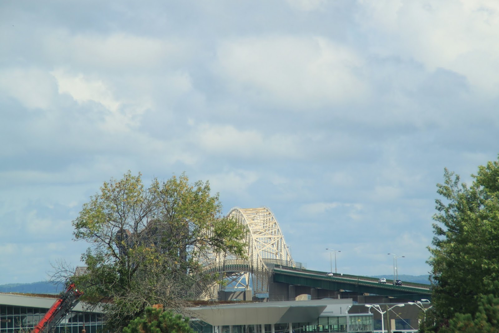 |
| Our first view of the Sault St Marie International Bridge going across the water to Sault St Marie, Canada. The bridge is 2.8 miles long. |
 |
| This was the view out the front window of our rig. It is the St Marys River (historically, no apostrophe is used in the name) and the ships passing through are so huge that taking a photo is almost impossible unless you are a distance away or taking the shot at an angle. |
 |
| The largest are 1,000 feet long. They are all going through the Soo Locks which connect Lake Superior with Lake Huron. |
 |
| The St Marys River doesn't look that wide or deep. |
 |
| From our rig we could even see Canada on the other side. |
 |
| But the river is big enough to handle one of these jumbo ships heading into the locks. |
Lake Superior is fed by over 300 rivers and streams. It's only outlet is the St Marys River which carries about 42 billion gallons of water from the lake every day. (Yep, that's right, 42 billion gallons every day). Seventy percent of the water flows down the front section of the St Marys with the remainder going around an island on the east side. The water travels down the river for 21 miles at a typical speed of 2 miles per hour which is considered quite fast for navigating.
The Soo Locks are a set of parallel locks enabling ships to travel between Lake Superior and the lower Great Lakes. The locks pass an average of 10,000 ships per year despite being closed during the months of January through March with the two cities named Sault St Marie located on either side of the river.
 |
The weather was hit and miss while we were there so we scurried about taking pictures whenever we could. Ships can easily pass under the International Bridge. Below the bridge you can see what looks like metal twisted backwards. It is a single railroad line used for trains to cross back and forth between the US and Canada. The railroad line is "pulled back" unless a train is ready to cross and then the railroad tracks are lowered to accommodate the train.
|
 |
| Downtown Sault St Marie is a very quiet town. The population is less than 15k while its sister city in Canada has a population of almost 80k. That's why the closest Wal-Mart store is on the Canadian side, eh! |
 |
| We drove into town and took a walk along the Soo Locks. We saw several ships moving through the locks. |
 |
| The water drop between Lake Superior and the St Marys River on the Lake Huron side is 21 feet. The ship in the distance is being lowered to the river level. |
 |
| This ship was closer to us and was coming into the Poe Lock from the St Marys River side. |
 |
| Workers at the Soo Locks tie the ship to the side as the water raises. |
 |
| Looking down at the ship in the lock. |
 |
| Once the ship is tied in place it takes about 15 minutes to raise or lower the water so the ship can pass through. |
 |
| Ship members waiting as the lock raises the water. |
 |
| Another view of the International Bridge in the background from the Soo Locks. |
 |
| While we watched, this large ship was also heading into the locks. |
 |
| Wow! That was exhausting so we found a neat establishment in town to discuss what we had seen. |
 |
| They had wonderful margaritas (and it was happy hour) so we had a few. |
We took a drive north on the peninsula and stopped at Tahquamenon Falls State Park to take the pups for a hike.
 |
| Tahquamenon rhymes with phenomenon. |
 |
| The upper Tahquamenon Falls are 200 feet across with a drop of 48 feet. |
 |
| The brownish color you see in the water is from tannin leaching out of the cypress and hemlock swamps into the river. |
 |
| This tree looks like it was a woodpecker's delight. |
 |
| We also saw the lower falls. |
We drove further up the peninsula to Whitefish Point to see a lighthouse and the Great Lakes Shipwreck Museum. This was a very rural area with few towns and little population. The museum was in Whitefish Harbor on the coast of Lake Superior. There have been many ships that have sunk in this area mainly due to the ferocity of the lake. Lake Superior is the largest of the Great Lakes, 160 miles wide and 350 mile long. The depth is over 1,300 feet in some areas and the surface area is approximately the size of South Carolina.
 |
| There is a desolate 80-mile stretch that extends from Whitefish Point west to the Pictured Rocks near Musining. Over 300 recorded accidents along this shipwreck coast claimed the lives of 320 sailors. Raging northwesterly storms that build over a 200 mile sweep of open water, along with poor visibility and heavy traffic in converging shipping lanes, have contributed to the loss of ships and men. This area of Whitefish Point is called, "Graveyard of the Great Lakes". |
 |
| The day we were there it turned sunny but the wind was gusting to 40 mph making the beach very cold. |
 |
| Whitefish Point Lighthouse is the oldest, still active lighthouse on Lake Superior and started operating in 1849. Notice the structure of the lighthouse is open and the upper portion has a walkover from the main structure. After several years, the original lighthouse was so damaged they rebuilt this one so the howling winds and the raging waters could not take it down. The lighthouse keeper was able to crossover to maintain the light and fog signal without having to walk through gale force winds. |
 |
| The rudder and tiller from the M.M. Drake shipwrecked 6 miles west of Whitefish Point in 1901. |
 |
| A salvaged anchor from another shipwreck. |
 |
| The prisms of light in a lighthouse. |
The most famous ship to sink in Lake Superior was the Edmund Fitzgerald loaded with 29,000 tons of taconite pellets destined for Detroit. The ship was 729 feet long with a crew of 29 and was lost on November 10, 1975, just 17 miles northwest of Whitefish Point, Michigan. Singer Gordon Lightfoot inspired popular interest in this vessel with his 1976 ballad, "The Wreck of the Edmund Fitzgerald". While no one knows what truly happened to the ship, there have been many opinions including negligence by the captain, a record storm of monumental size, overloading of the ship, and deck locks that were not securely fastened causing the ship to fill with water. Three underwater expeditions to the wreck in 1989, 1994, and 1995 were unable to determine why it sank.
 |
| At the request of family members surviving the crew, Fitzgerald's 200 lb bronze bell was recovered and is on display at the museum as a memorial to her lost crew. |
 |
This model was started by an educator as a way to teach his high school students about Great Lake shipping. Made entirely from Lego's, it took 9 years and 18,000 pieces to create a 12 foot, 9 inch model of the ship.
|
Back in Sault St Marie we took a hike up the Tower of History which was built in 1968. The Tower has information about the early missionaries who came to this area along with local and Native American history.
 |
| An example of bead decorations by the Chippewa Indians. Note the beaded holster on the right. |
 |
| These elk hooves were used as footwear to deceive anyone attempting to track the person wearing them. |
 |
| This large, long building on the St Marys River is the Edison Sault Power Plant built in 1902. The plant is fed by a water canal 2 1/2 miles long that has been diverted from the main river. It is the world's longest horizontal shaft turbine with 2 turbines located in 80 penstocks. The plant generates 225 million kilowatt hours annually. |
 |
Recognized as an historic landmark in Sault St Marie,Michigan, the sandstone building was crafted by Italian masons. The construction started in 1898 and they used stone that was excavated from the power canal in 1885. Studies have shown that the structural integrity of the plant is sound and should last indefinitely.
|
 |
| Views of St Sault Marie from the Tower of History. |
 |
| The steam in the distance is a huge power plant on the Canadian side of the river. |
While in the city, we decided to take a 2-hour tour boat ride through the Soo Locks. The first iteration of the Soo Locks was completed in 1855. The US locks form part of a 1.6 mile canal that is owned and operated by the United States Army Corps of Engineers.
 |
| It was a cool day but we had blue skies. |
 |
| Originally there were four locks but two have been closed because they weren't large enough to handle the big vessels. This is the tour boat entering one of the locks. |
 |
| The locks are starting to close. |
 |
| The two remaining locks in use are the Poe and the MacArthur. The Poe Lock, originally built in 1895 was rebuilt in 1968 to accommodate larger ships after the St Lawrence Seaway opened. It is 1200 feet long and 110 feet wide and is the only lock that can handle the large lake freighters on the upper lakes. In this picture we are in the Poe Lock. |
 |
| The machinery that opens and closes the gates to the locks is powered by electricity generated by the river and produced in a hydroelectric plant alongside the locks. The water is transferred through valves located at the bottom of the locks. These are gravity fed, using no electricity and no mechanical pumps. The water is simply allowed to seek its own level. |
 |
| Leaving the locks we are heading under the International Bridge toward Lake Superior. |
 |
| Beautiful and cold Lake Superior. |
 |
| A freighter we passed behind as it was heading toward the locks. |
 |
| On the Canadian side of Lake Superior we saw a steel operation plant and this large crane emptying scrap into trucks. |
 |
| After touring the Canadian side we headed back to where we began but this time we went through the only Canadian lock. |
 |
| It is a much smaller lock and is maintained by Canada and only used for pleasure craft. |
 |
| A Canadian Coast Guard boat. |
 |
| Viewing the city on the Canadian side. |
 |
| While in town we heard about the 'Barmuda Triangle' which is 13 different bars in a three block radius. So we checked a few out. |
 |
| You can't go wrong with beers named The Widowmaker, The Horny Monk, and Vanilla Java Porter! |
 |
| Sunrise on St Marys River and |
 |
| sunset looking at the International Bridge and Sault St Marie, Canada. |
 |
| Finally, how could anyone disagree with this service. |
We had a great time in Sault St Marie and are heading next to Musining, Michigan, to view the Pictured Rocks. For those who are interested, additional pictures we've taken of the areas we visit can be seen by clicking on 'High Hopes Album' at the top of each blog. Peace!


No comments:
Post a Comment