We left Montana on our way to Idaho and drove through the Lolo Pass. The pass is 5,300 feet up so it was a bit of a climb. When we reached the top of the pass it was the border between Montana and Idaho. A beautiful area so we took a break and got an Idaho map at the tourist stop. Leaving there the highway reduces to a two lane road with a sign that says, "Caution - winding road next 99 miles". Boy, they weren't kidding. It was a 5.5% grade going down so we used the exhaust breaks most of the way and kept it around 35 mph most of the time.
 |
| Looks gentle but it's a downhill trip with lots of turns. |
 |
| Beautiful mountains. |
 |
| Idaho is a magnificent state. |
We arrived in a Grangeville in an area called the Camas Corridor. The Nez Perce Indians lived and traveled throughout this area for centuries. A favorite and major food source was the blue-flowering camas bulb. Early travelers to the area remarked that when the camas was in bloom parts of the prairie appeared to be a large body of water.
 |
| Blue Camas Field |
This land at one time was the home of the of the Nez Perce Indians and they were a peaceful tribe that had allowed thousands of settlers into their homeland. Lewis and Clark found the Nez Perce to be one of the friendliest tribes they encountered. Following discovery of gold in Pierce, Idaho, their lands were diminished by a treaty in 1863. Several bands, including Chief Joseph, refused to sign the treaty and a war began. The war lasted for four months and covered over 1,500 miles from Idaho to Montana where the Nez Perce were defeated.
One hundred and fifty years later, the area is now a patchwork quilt of wheat, canola, and oat fields over a rolling landscape. What is so amazing is that you are 3,000 feet up in the mountains when you come to this area. If it wasn't for the mountains you would think you were in Kansas.
 |
| Fields of wheat with the mountains in the background. |
 |
| It was harvest time and you can see the combines in the background. |
We were surprised that there weren't many hiking trails in this area. A few miles from Grangeville, and a drop down to 1,800 feet in altitude, we found a path to hike. The mountains are very steep and the one trail we took had a lot of switchbacks in order to climb it. The actual path was barely a foot wide and the drop was straight down so one had to be very careful. It was a hot day when we hiked and after awhile I started to get dizzy from the heat so we decided to go back down.
 |
| A view of our car (you can barely see it) from the path up the mountain. |
 |
| Another view from where we were....and you wonder why I was getting dizzy! |
 |
| Luckily right across the road from where we started the hike was the South Fork of the Clearwater River. |
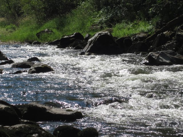 |
| A great place to have our lunch and let the pups cool off in the water. |
 |
| Happy, cooled off Lucy. |
The Monastery of St Gertrude, near the town of Cottonwood, was founded in 1907 by Benedictine Sisters who moved from Washington after a local resident offered the sisters 85 acres of land if they would move to the Camas Prairie. In 1919, building began on the convent and it was made of blue porphyry stone that was found on their land. Construction took 5 years with the sisters working alongside the hired men. The chapel has twin towers that are 97 feet tall and the interior chapel features an ornately carved altar imported from Germany.
 |
| Beautiful chapel |
 |
| A figurine created by one of the sisters made from copper tubing. The stone in the background is an example of the blue porphyry stone used to build the monastery. The blocks are very large. |
 |
| A closer view of the chapel. |
 |
| Magnificent chapel |
 |
| The sister told us that she had just found out recently that her grandfather was one of the men who had helped assemble the altar in 1928. |
 |
| View of the Camas Prairie from the Monastery of St Gertrude. |
For our trivia buffs:
Which is the third largest county in the United States?
It's Idaho County, larger than Rhode Island, Connecticut, and Delaware combined, and the home of the Camas Prairie, four national wilderness areas, and four national parks totaling over 5.5 million acres.
Our next stop is in McCall, ID, at an elevation of 5,000 feet. This is a resort town nestled next to Payette Lake and the Ponderosa State Park. Peace to all !
For additional pictures: https://picasaweb.google.com/118305421752208972550
No comments:
Post a Comment