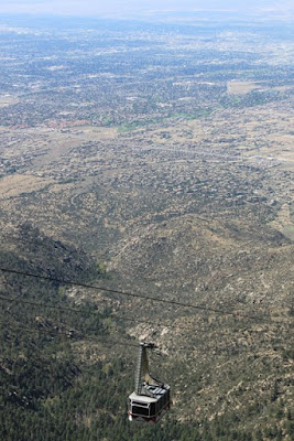
Some rifts form basins such as the Rio Grande that over millions of years fill with sediment. At Albuquerque, the basin sediments are three miles deep. The rift continues to widen today, although very slowly, 0.5 to 2 millimeters per year, and as it widens the mountains become taller and the valley sinks lower.
 |
| A view of Albuquerque from the mountains. The big chunk of dirt on the right is the Rift in the Rio Grande Basin. |
Since we had so much fun hiking in Santa Fe, we decided to do even more in Albuquerque. Our first stop is locally known as the Albuquerque Volcanoes or the Three Sisters. Instead of the 'magma' rising through a vertical central vent as most volcanoes do, these volcanoes are a rare example of a fissure eruption that is over five miles long and resulted in a row of aligned craters.
 |
| View of the three volcanoes from a distance. |
 |
| Max is king of the hill on a bed of lava. |
 |
| Reminds me of something on another planet. |
 |
| Albuquerque is in the distance. The volcanoes are 250 feet high. |
On our second day we decided to climb Sandia Crest in the Sandia Mountain Range of the Cibola National Forest. What a cool place......literally.....it is 20 degrees cooler in the mountains than down in Albuquerque. The first day we hiked it was only 55 degrees.
 |
| Changing colors in the mountains. Fall really is coming.....honest! |
Our hike was 3.25 miles with an elevation gain of 625 feet. That's because you are starting at 10,000 feet when you begin the climb. It was an easier trail that offered beautiful views of the city and surrounding mountains
 |
| Climbing the Sandia Mountains. |
 |
| Albuquerque from the Sandia Peak. |
 |
| Another view of the very large city. We were at the 10,678 foot level. |
 |
| What a view. |
 |
| In some areas the wild flowers were still in bloom in meadows between the tree lines. |
We had such a great time we decided to hike the mountains again. The next day was a Saturday so there were more people using the trails. The trail we took on this day was called the 10k trail because it ran along the 10,000 foot elevation level. From where the trailhead started we descended a good distance before the trail changed and we climbed upward 1410 feet and covered 6.5 miles. Yes, we are gluttons for punishment! There were a lot of other people getting ready to hike at the same area we were in and most of them had their dogs along. Surprisingly, throughout the whole hike we only met two other people on the trail and never ran into any of the other dogs.
 |
| Lots of rocks and trees. |
 |
| The stones on the path were shiny from the effect of weather and the many previous hikers who used trail. |
 |
| Fallen trees was a common theme throughout the walk. The wind and elements are very powerful near the top. |
 |
| I love this picture. Millions and millions of Aspens. |
 |
| It was a gorgeous hike. |
 |
| Another mountain view. |
We were exhausted. I went through my gasping routine several times before we got to the top. Even the dogs were wasted but we still had a good time. Of course, knowing we were heading south the next day also relieved us of the thought that we would be doing it again soon. But we plan on being back next year because they have many other trails we haven't explored yet.
The RV park we stayed at provides picnic tables to the residents. Thought you might like to see this one. Since Albuquerque is in the valley it is hotter and extremely dry. The soil is cracked and there is little moisture or plants unless you use tons of water. We like the mountains much better than the city.
 |
| Would you want to plop your butt on that ??? |
Next stop is San Antonio, Texas. Peace to all!
For our trivia buffs:
The population of Albuquerque is growing rapidly and is expected to hit 2 million by 2030. The city, however, only receives 6 to 9 inches of rain each year and is considered an arid climate. Where do they get their water from?
Fifteen thousand feet of water-deposited sand and mud now fill the basin underneath the city. Most of Albuquerque's water is trapped in the pore spaces of this sediment.

No comments:
Post a Comment