 |
| We left Las Vegas and it was raining again. |
 |
| The Las Vegas International Speedway. There was a big Nascar race coming up so the RV tail-gaters were coming in. |
 |
| Utah's greeting wasn't much better as far as the weather was concerned. |
 |
| Heavy clouds but you could still see the red soil. |
 |
| We drove to Hurricane, UT, and stayed at the Sand Hollow State Park. This was a view of the mountains from our site. The clouds were resting on the ridges. |
 |
| Sunset was magnificent and we caught these photos. |
 |
| Another favorite! Looks like one of the mountains exploded. |
 |
| The next day was bright and clear. What a difference. |
 |
| Our rig with the mountains behind it. Not too shabby to wake up to each day! |
Our first trip was to Zion National Park. Mormon pioneer Isaac Behunin is credited with building one of the first cabins in Zion Canyon in 1863. Gazing in awe, he called the canyon, Little Zion, an Old Testament reference to a "place of safety or refuge".
Zion was little visited during the 19th century until 1908 when a surveyor mapped the upper Virgin River. The report was so persuasive that President Taft created Mukuntuweap National Monument. By 1919, it had been enlarged and renamed Zion National Park.
 |
| Driving into Zion even the paved roads were red colored. |
 |
| The Virgin River often looks like a tranquil stream except during spring runoff or after a rainstorm. The water fills with particles of sandstone and can carry an average of 5,000 tons of rock fragments daily. The river not only carved Zion but also continues to widen and transform the scenery. |
 |
| Zion Canyon is 15 miles long and a half mile deep cut through reddish and tan Navajo sandstone. The elevation is 3,666 ft in the lowest elevation and 8,726 ft at its highest. The park includes mountains, canyons,buttes, mesas, and natural arches. |
 |
The park consists of million of years of warm, shallow seas, streams, ponds and lakes, and vast deserts that covered the area. Water action laid down many of the rocks as sand, gravel, mud, and limy ooze. These were then consolidated into sandstones, shale, and limestone by the weight of layers above them and their grains were cemented.
|
 |
| The formations of Zion settled one above the other, in orderly succession. Seven formations are displayed within the park |
 |
| Embedded in the rocks are occasional fossil sea shells, fish, trees, snails, and bones and tracks of land animals that lived here. |
 |
| Huge sections of rock break away leaving open cuts or smooth looking walls. |
 |
| Water is continually seeping through the sandstone causing erosion and new formations. |
 |
This is named the Great White Throne.
|
 |
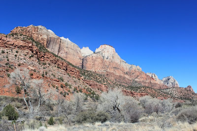
| The rock formation colors were very vibrant. |
 |
| We hiked a trail to one of the Emerald Pools. |
 |
| A nice hike through the walls of rock. |
 |
| The lower Emerald Pool was pretty shallow but still a haven for the animals that live here. |
 |
| Over time, the sandstone eroded and arches were formed. This one was well on its way....and it may be open in another million years or so. |
 |
| If you decide to drive through Zion National Park you must go through the Zion-Mt Carmel Tunnel. This tunnel was completed in 1930 opening the region to tourism and linking Zion to Bryce Canyon and the Grand Canyon's North Rim. |
 |
Work on the tunnel began with drilling small shafts into the north facing cliff. Those shafts later became the tunnel's windows letting light in and giving the workers places to expel rubble. The four windows are the only source of light in the tunnel today. Driving up to the tunnel we were trying to figure out what the opening was that we could see from the road. It was one of the windows.
|
 |
| The tunnel itself has become a kind of barrier because today's RVs and tour buses are too large for two-way traffic through the tunnel. Expect delays as oncoming traffic is stopped at one end to allow the oversize vehicle to pass through. There is also a $15 charge to stop the traffic. We drove through in our car and it was scary how pitch black it was inside. The little bit of light that came from the four windows wasn't much help. I can't even imagine driving our rig through it. |
 |
| Another day we decided to drive up to Bryce Canyon National Park which was about 2.5 hours from where we were staying. We enjoyed the colorful rock formations along the way. |
 |
| On our way there we decided to drive through Dixie National Forest. |
 |
| We were at 9,700 feet elevation and there was lots of snow. We saw some beautiful views but the road was very twisty-turny. |
 |
| We stopped for awhile and let the pups play in the snow. |
 |
| Here's the Captain trying to get out as he sank up to his thighs in a snow bank. I got this shot from the front seat of the car :) |
 |
| The sun was shining and the snow looked like sparkling diamonds. |
The Bryce Canyon area was settled by Mormon pioneers in the 1850's and was named for Ebenezer Bryce who homesteaded in the area in 1874. He built a road to the plateau to retrieve firewood and timber and a canal to irrigate his crops. He grazed his cattle inside what are now the park's borders. When asked what he thought of the area, Bryce, a man of few words supposedly stated, "it was a hell of a place to lose a cow".
Viewing Bryce Canyon National Park is completed mainly by car unless you are into hiking or wilderness backpacking. The park is very primitive and beautiful and this time of year there was a heavy layer of snow so we opted for driving. They recommend you start at the farthest end of the park and drive back stopping at the different designated overlooks.
 |
The Paunsaugunt Plateau was once connected to another plateau 30 miles across the valley. When the Rocky Mountain region began rising 16 million years ago, north-south faults split the tableland into seven separate plateaus. This plateau is 9,100 feet above sea level but almost 2,000 feet lower than the plateau it split from.
|
 |
In Bryce Canyon there are over 200 freeze/thaw cycles each year. Melting snow, in the form of water, seeps into cracks and freezes at night. The freezing water expands by almost 10% slowly prying cracks open to the elements. As the plateau begins to erode it creates large sections of stone called a 'fin'.
|
 |
The next stage is aptly called 'the window'. This arch began as a recess in a narrow limestone fin. Moisture seeping into the cracks and freezing and thawing, combined with gravity and chemical weathering, eroded the rock. Though the water gully beneath it did not carve the arch, the runoff washed away debris and deepened the span.
|
 |
| The beginning of another window. |
 |
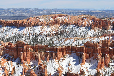
| Bryce Canyon is most famously known for the rock formation called a 'hoodoo'. This is the fourth stage of erosion and is called the Claron Formation. |
 |
In addition to frost wedging, the rain helps to sculpt the hoodoos. Even in Bryce Canyon there is slightly acidic rainwater and over time it slowly dissolves the limestone grain making round edges on the hoodoos and giving them lumpy and bulging profiles.
|
 |
| Within the hoodoo where internal mudstone and siltstone layers interrupt the limestone, the formation will be more resistant to the chemical weathering. |
 |
| Many of the more durable hoodoos are capped with a special kind of magnesium-rich limestone called dolomite that dissolves at a much slower rate so that it protects the weaker limestone underneath. |
 |
| The hoodoos can range in size from that of an average human to heights exceeding a 10-story building. Minerals deposited within the different rock types cause hoodoos to have different colors throughout their height. |
 |
| From a distance, the hoodoos can even look like medieval castles with fortresses protecting them. |
 |
Unfortunately, hoodoos don't last very long. The same processes that create hoodoos are equally aggressive in their destruction. The average rate of erosion is calculated at 2-4 feet every 100 years.
 |
| An example of erosion caused by the elements. The soil is very sandy underfoot. |
|
We really enjoyed both national parks but I think our favorite was Bryce Canyon. We hope to come back again, when the weather is warmer, so we can spend some time hiking the day trails. They say walking amongst the hoodoos is really the best way to experience them. Until then we still have some wonderful pictures of the area.
 |
| Ponderosa Point at 8900 feet. |
 |
| Aqua Canyon and Farview Points at 8800 feet. |
 |
| Sheep Creek Swamp Canyon |
 |
| Bryce Point down at 8300 feet elevation. |
 |
| Inspiration Point. Unbelievable! |
 |
| Our final sunset before we leave Utah. |
Time to start heading home. We had planned on driving through southern Utah and Flagstaff, AZ. Wrong! The main artery heading south takes you through Page, AZ, and several weeks ago they had a section of the highway 25 miles below Page that unexpectedly collapsed. You may have read about it in the newspaper. Scientists and geologists aren't sure what happened but believe that some type of ground change within the earth caused it. Needless to say, it will be awhile before it is fixed so alternate routes have to be taken. That was okay with us but then a blizzard hit the area including Flagstaff. When the Captain called ahead to the RV park they told him they didn't think they would even be open. Thinking about driving this rig through the mountains with snow on the roads wasn't too calming so the Safety Director (guess who) made the decision to backtrack down through Vegas and across to Texas. Hey, we heard about a neat town called Fredericksburg, TX, that has a German theme. Sounds like a plan. Peace!


No comments:
Post a Comment